
Arid Landforms and Cycle of Erosion
- Arid regions are regions with scanty rainfall. Deserts and Semi-arid regions fall under arid landforms.
Erosional Arid Landforms
Water Eroded Arid Landforms
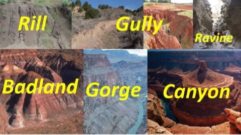
Rill
- In hill slope geomorphology, a rill is a narrow and shallow channel cut into soil by the erosive action of flowing water.
Gully
- A gully is a landform created by running water. Gullies resemble large ditches or small valleys, but are metres to tens of metres in depth and width.
Ravine
- A ravine is a landform narrower than a canyon and is often the product of stream cutting erosion. Ravines are typically classified as larger in scale than gullies, although smaller than valleys.
Badland Topography
- In arid regions occasional rainstorms produce numerous rills and channels which extensively erode weak sedimentary formations.
- Ravines and gullies are developed by linear fluvial erosion leading to the formation of badland topography.
- Example: Chambal Ravines.
Bolsons
- The intermontane basins in dry regions are generally known as bolsons.
Playas
- Three unique landforms viz. pediments, bajadas and playas are typically found in bolsons.
- Small streams flow into bolsons, where water is accumulated. These temporary lakes are called playas.
- After the evaporation of water, salt-covered playas are called salinas.
Pediments
- In form and function there is no difference between a pediment and an alluvial fan; however, pediment is an erosional landform while a fan is a constructional one.
- A true pediment is a rock cut surface at the foot of mountains.
Bajada
- Bajadas are moderately sloping depositional plains located between pediments and playa.
- Several alluvial fans coalesce to form a bajada.
Wind Eroded Arid Landforms
- The wind or Aeolian erosion takes place in the following ways, viz. deflation, abrasion, and attrition.
- Deflation == removing, lifting and carrying away dry, unsorted dust particles by winds. It causes depressions known as blow outs.
- Abrasion == When wind loaded with sand grains erodes the rock by grinding against its walls is called abrasion or sandblasting.
- Attrition == Attrition refers to wear and tear of the sand particles while they are being transported.
Deflation basins
- Deflation basins, called blowouts, are hollows formed by the removal of particles by wind. Blowouts are generally small, but may be up to several kilometers in diameter.
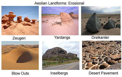
Mushroom rocks
- A mushroom rock, also called rock pedestal or a pedestal rock, is a naturally occurring rock whose shape, as its name implies, resembles a mushroom.
- The rocks are deformed in a number of different ways: by erosion and weathering, glacial action, or from a sudden disturbance. Mushroom rocks are related to, but different from, yardang.
Inselbergs
- A monadnock or inselberg is an isolated hill, knob, ridge, outcrop, or small mountain that rises abruptly from a gently sloping or virtually level surrounding plain.
Demoiselles
- These are rock pillars which stand as resistant rocks above soft rocks as a result of differential erosion of hard and soft rocks.
Zeugen
- A table-shaped area of rock found in arid and semi-arid areas formed when more resistant rock is reduced at a slower rate than softer rocks around it.
Yardangs
- Ridge of rock, formed by the action of the wind, usually parallel to the prevailing wind direction.
Wind bridges and windows
- Powerful wind continuously abrades stone lattices, creating holes. Sometimes the holes are gradually widened to reach the other end of the rocks to create the effect of a window—thus forming a wind window. Window bridges, are formed when the holes are further widened to form an arch-like feature.
Arid Depositional Landforms
- Landforms are also created by the depositional force of wind. These are as follows.
Ripple Marks
- These are depositional features on a small scale formed by saltation (he transport of hard particles over an uneven surface in a turbulent flow of air or water).
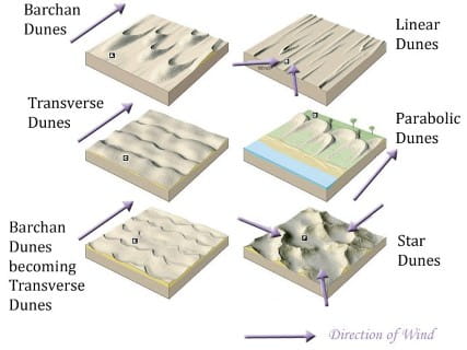
Sand dunes
- Sand dunes are heaps or mounds of sand found in deserts. Generally their heights vary from a few metres to 20 metres but in some cases dunes are several hundred metres high and 5 to 6 km long.
Longitudinal dunes
- Formed parallel to the wind movement. The windward slope of the dune is gentle whereas the leeward side is steep. These dunes are commonly found at the heart of trade-wind deserts like the Sahara, Australian, Libyan, South African and Thar deserts.
Transverse dunes
- Dunes deposited perpendicular (transverse) to the prevailing wind direction.
Barchans
- Crescent shaped dunes. The windward side is convex whereas the leeward side is concave and steep.
Parabolic dunes
- They are U-shaped and are much longer and narrower than barchans.
Star dunes
- Have a high central peak, radically extending three or more arms.
Loess
- In some parts of the world, windblown dust and silt blanket the land. This layer of fine, mineral-rich material is called loess.
- Extensive loess deposits are found in northern China, the Great Plains of North America, central Europe, and parts of Russia and Kazakhstan.
- The thickest loess deposits are near the Missouri River in the U.S. state of Iowa and along the Yellow River in China.
- Loess accumulates, or builds up, at the edges of deserts. For example, as wind blows across the Gobi, a desert in Asia, it picks up and carries fine particles. These particles include sand crystals made of quartz or mica. It may also contain organic material, such as the dusty remains of skeletons from desert animals.
- Loess often develops into extremely fertile agricultural soil. It is full of minerals and drains water very well. It is easily tilled, or broken up, for planting seeds.
- Loess usually erodes very slowly – Chinese farmers have been working the loess around the Yellow River for more than a thousand years.